By Thomas G. England, ME&A GIS Analyst, and Ricky Perez Leon, ME&A GIS Analyst
In a world where interpreting quantitative and qualitative data is crucial to making informed decisions, Geographic Information Systems (GIS) have become an essential tool for producing powerful analytical visualizations. These visualizations enable users to rapidly understand variable tendencies, patterns, and distribution via maps attached to data statistics. By linking alphanumeric data to cartographic layers, GIS is the most reliable tool for analyzing and visualizing data from a territorial perspective. This enhances decision-making when location is crucial for programming resources and modeling activity impacts in a timeline with a geographical approach.
ME&A has proven the effectiveness of using GIS tools to collect, manage, analyze, and visualize data to provide evidence of activities’ development and performance for our clients, including USAID and the U.S. Department of State. For the past eight years, ME&A has used GIS from data collection to producing static and interactive maps with dynamic dashboards to providing a reliable tool for transforming alphanumerical data into information useful for making data-informed decisions under monitoring, evaluation, and learning (MEL) activities. From MEL platforms to performance evaluations, ME&A has used multiple GIS tools and techniques for collecting data and transforming it into appealing visuals:
- Spatial Analysis. GIS supports ME&A MEL activities through statistical and geospatial analysis of context indicators and performance of USAID activities in different countries, including Armenia, Bangladesh, Guatemala, El Salvador, Rwanda, and Tanzania. For this purpose, ME&A has collected quantitative data from USAID implementing partners, government institutions, and other stakeholders to link with spatial layers to enable the spatial analysis of the data. The analysis included indicator trends, correlations, geologic mapping, and geostatistical relationships with activities’ locations. With the analysis results, ME&A built maps for USAID and host country government leaders to inform decision-making for adapting and programming activities. To monitor and evaluate the indicators and activity execution, ME&A repeated the analysis at different times according to USAID requests.
- Data Collection. ME&A uses ArcGIS Survey123 as an integral part of our GIS work because of its robust capabilities to gather data seamlessly attached to geographical locations. For example, when ME&A provided third-party monitoring services for the USAID Bureau for Humanitarian Assistance in Nicaragua, Survey123 helped ME&A collect data on the humanitarian assistance provided to Nicaraguan communities; the data was collected by disaggregating gender and age to identify the groups that were most benefitted and to locate where these beneficiaries were distributed in the country. Also, ME&A has used Survey123 for collecting quantitative data during mid-term and final evaluations for USAID and the U.S. Department of the State in Bangladesh, Cambodia, Jordan, and Turkey and currently in Costa Rica, the Dominican Republic, Honduras, Mexico, and Panama.
- Data Management. ME&A uses ArcGIS Pro as the primary spatial data management tool to produce static and dynamic maps and prepare data sets. For example, the data collected through Survey123 is brought to ArcGIS Pro for sub-setting and formatting into sub-datasets for analysis. The spatial data ME&A uses and produces is securely stored and organized in geodatabases, a library format used in ArcGIS that harbors spatial and non-spatial data. ME&A manages the spatial data in compliance with USAID Automated Directives System (ADS) requirements and maintains high levels of cyber security through strict internal security regulations. The data management step is critical for analysis, and ME&A carefully allots sufficient time and resources for this activity.
- Data Visualization. ME&A believes GIS visuals are most useful when the data is transformed into dynamic and interactive applications. We have learned that static maps are not enough to forward data-driven decision-making; this is the main reason for developing interactive dashboards to communicate evidence in an easy-to-understand format where users interact with the data to obtain detailed maps, charts, texts, and media according to their specific needs. ME&A believes data becomes most useful with the ability to transform it into evidence-based knowledge for decision-making. In El Salvador, ME&A produced interactive dashboards for USAID, allowing mission personnel to pinpoint the location of activities in maps, analyze trends of the activity performance and execution, identify beneficiary trends through timelines, and determine gaps where activities must be reinforced.
- Decision Support. ME&A always focuses on the end goal of a well-built GIS platform to enable informed decision-making. Through indicator-driven, geospatially enhanced evidence and by communicating that evidence through visualizations, ME&A can support clients’ decision-making. With GIS, ME&A has provided information for budgeting, programming, resource allocation, natural resources management, policy, and portfolio review decisions. In El Salvador and Guatemala, ME&A provided maps of the activities per development objective for USAID annual planning meetings, helping to identify municipalities to program interventions.
ME&A will continue using GIS and enhancing human resources and technology to ensure our future services provide the most accurate, reliable, and sufficient information our clients need worldwide.
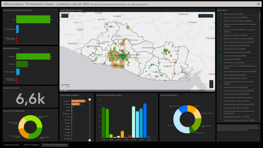
The USAID Mission in El Salvador requested an interactive dashboard to visualize the distribution of humanitarian assistance provided to the Government of El Salvador to reduce the impact of tropical storms Amanda and Cristobal occurring consecutively in late May/early June 2020.
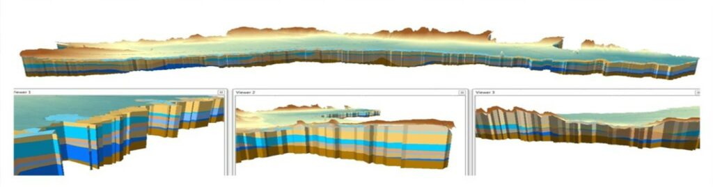
ME&A developed a GIS-based Decision Support System on behalf of USAID for the Government of Armenia providing 3D models detailing the Ararat Valley’s hydrogeologic structure and water bearing potential.
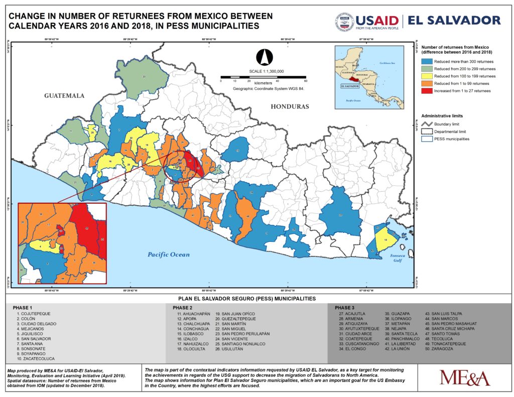
A GIS map ME&A created to enable USAID and U.S. Embassy officials in El Salvador and Washington, D.C., to better understand the economic, and social challenges facing El Salvador was one of eight maps displayed at the 2019 Esri User Conference.